 Girraween
National Park
Girraween
National Park
Girraween
National Park
Girraween is situated 260 Km southwest of Brisbane via Stanthorpe.
The granite landscape of the New England highlands, is well preserved in Girraween National Park with its granite outcrops and boulders, scenic creeks, open eucalypt forest and heath. The park is renowned for its wildflower displays from September to November. A wealth of wildflowers becomes a blaze of colour as they burst into life and cover the countryside. There are ground orchids, tufted irises, daisies, flannel flowers, native bluebells, rock roses and pea-flowering plants. Birds along the paths and flitting from tree to tree will delight the many visitors to the park. Walking trails to spectacular features, creeks and lookouts provide a range of walks. There are a number of easy to follow walking tracks ranging from short to very long distances. A popular track is the 5 km Junction Track. This track takes about two and a half hours to negotiate.
Girraween is located east of the New England Highway, 15km north of Wallangarra and south of Ballandean and Stanthorpe. The name Girraween is aboriginal for "place of flowers".
The park which is very popular, has a large picnic area on Bald Rock Creek and is suitable for swimming. Two camp grounds have facilities and unpowered caravan sites. Girraween experiences temperature extremes and visitors should prepare for nights below freezing in winter months.
Above the falls are delightful pools surrounded by green forest. Bathing in the additional moisture below the falls is a rainforest gully.
The Boonoo Boonoo river is one of the park's most spectacular features winding its way through high granite country, strewn with boulders and covered by open forest.
Riverside vegetation includes banksias, melaleucas, grevillia, callitris, leptospermum and callistemon. The landscape along the river includes bare, smooth stretches of granite, dotted with tea tree, large pools with sandy banks lined with cypress pine, massive boulder-strewn stretches and secluded rocky pools.
A majestic dark pool is the final attraction before the river slides over the falls.
A graded walking trail descends from the main parking area to a viewing platform which affords impressive views of the falls and the sheer granite cliffs. A picnic area with amenities is located a the top of the falls. Both Bald Rock and Boonoo Boonoo are run by the New South Wales National Parks and Wildlife Service.
There is evidence of gold mining which took place during the 19th century in one of the tributaries of the Boonoo Boonoo River, at Morgan's Gully, where the remains of sluicing and old machinery can be seen. The road to the Boonoo Boonoo Falls, and the path down from the Falls Lookout are associated with Banjo Paterson's courtship and marriage.
(courtesy of the Natioanl Parks and Wildlife Service & Southern Downs Tourist Association) Back to the Top
Bald Rock is Australia's largest exposed granite rock and second largest rock in Australia.
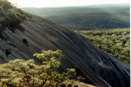 Bald Rock National Park is tucked
away in the thickly timbered country between Stanthorpe and Tenterfield
along the Queensland-New South Wales border, accessable to conventional
vehicles from the Mt Lindsay Highway. The park has two distinct
walking tracks, both leading to the top of the rock. These tracks
are clearly marked. From the top visitors are rewarded by expansive
views across a beautiful granite outcrop dotted landscape. Around
the base of the rock are stands of eucalypts, mainly stringy-bark
and New England blackbutt. The park has a small camping area for
those wishing to extend their stay and is just 39km from Stanthorpe.
Bald Rock National Park is tucked
away in the thickly timbered country between Stanthorpe and Tenterfield
along the Queensland-New South Wales border, accessable to conventional
vehicles from the Mt Lindsay Highway. The park has two distinct
walking tracks, both leading to the top of the rock. These tracks
are clearly marked. From the top visitors are rewarded by expansive
views across a beautiful granite outcrop dotted landscape. Around
the base of the rock are stands of eucalypts, mainly stringy-bark
and New England blackbutt. The park has a small camping area for
those wishing to extend their stay and is just 39km from Stanthorpe.
Mineral deposits - principally tin, copper and arsenic - were mined sporadically at Sundown from the 1870's. Remains of mining activity can be seen feom the 4WD track. While rich pockets of ore occurred, the deposits were mainly low-grade.
Though more than 70 men were employed for a short time, the mines were never a financial success. Old surface diggings are scattered throughout the Red Rock area.
Sundown is known locally as 'traprock' country. The hard dense rock was formed from ancient marine sediments deformed by heat and pressure. Intense minor faulting, folding and weathering has resulted in the existing layered rocks forming steep ridges and gorges and gorges leading down to the Severn River.
Intrusions of granite occur at Jibbinbar Mountain in the north-west and the deeply eroded Red Rock gorge. Two granite dykes run roughly parallel through the area. One forms Rats Castle, a local landmark, and can be traced through the park and across the road near the southern entrance.
Sundown's landscapes and vegetation contrasts sharply with the granite tors and valleys of the adjacent Granite Belt and Girraween National Park. The two parks provide interesting and different experiences for visitors.
![]()